


Deskripsi Polaris GPS Navigation: Hiking, Marine, Offroad
Easy-to-use high performance GPS for wherever your travels take you. No account setup or subscriptions required.
Turn your phone into a powerful GPS navigation system with Polaris Navigation GPS, the world's #1 all-purpose GPS, and dare to go where there are no roads.
Imagine... What would it be like to navigate any waterway or explore any wilderness or city using only your phone's GPS location abilities and a view of the sky? What it would be like to create navigation destinations without the need of an internet connection and find them using only an arrow or offline maps.
That is just a glimpse of the navigational power you will hold in your hands when you install Polaris Navigation GPS.
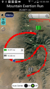
Used mostly as a hiking, off road, nautical and trail GPS app, Polaris is an excellent backup or replacement for your handheld dedicated GPS satellite navigation unit and will keep you oriented wherever your outdoor adventures take you!
Typical usage:
● Hiking GPS with the best hiking maps!
● Back country exploration and outdoor adventure
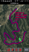
● Trail recorder
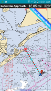
● Sailing, Boating. All marine navigation charts in Polaris are free.
● Fishing GPS. Find you favorite fishing hole.
● Hunting and hunting maps. Find you favorite hunting blind and your way back!
● Geocache
● Camping
● Mountain Biking and bike maps
● Backpacking and other outdoor sports
● Compass orienteering
Known for its stability, reliability and flexibility, Polaris is used by land-sea search and rescue, military personnel and millions of others worldwide.
To support your offline adventures we provide free of charge:
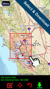
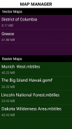
📡 Access to our vector & raster map downloaders (topos, marine, hiking and others).
📡 No limits on map types or on the number of map downloads.
📡 All maps are shown with high detail and large, easy to read labels.
This powerful navigation system also includes:
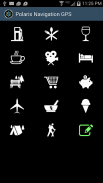
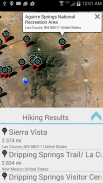
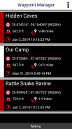
📡 Polaris Places Picker. Find hiking trails, camping locations and much more!
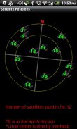
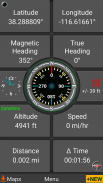
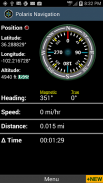
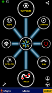
📡 GPS compass and magnetic compass
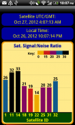
📡 GPS parameters panel
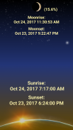
📡 Odometers, altimeters, speedometers, chronometers
📡 Split distances on tracks
📡 Draw a trail and navigate it
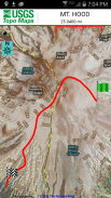
📡 Google Maps, OpenStreetMap-Mapnik, Topographic Maps, Cycle Route and Hiking Maps, Vector Maps, USGS Topo Maps, NOAA Marine Charts, World Aviation Operations Charts, Canada Toporama.
📡 Comprehensive set of GPS Tools and diagnostics
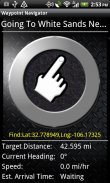
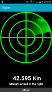
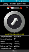
📡 Waypoint navigation system including a dynamic waypoint-finding compass that always points to your destination while reporting estimated time of arrival, distance to target and other statistics. Just follow the arrow!
📡 Trail navigation system
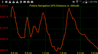
📡 Altitude profiles
📡 Location sharing
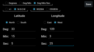
📡 Supports British OSGR and OSGB-36 DATUM (Ordnance Survey Grid)
📡 Coordinate formats: latitude/longitude as degrees, deg:min, deg:min:sec, and UTM (Universal Transverse Mercator).
📡 Military Coordinate Finder - Military Grid Coordinate Reference System (MGRS).
📡 Hiking Trails - Most of the maps show hiking paths courtesy of the Openstreetmap project. We are always amazed to find that even some of the most obscure hiking routes in our state are available.
⚓ Marine navigation- NOAA Nautical Charts and nautical unit reporting.
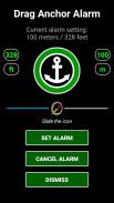
⚓ Drift alert / Drag anchor alarm.
📡 Select source for altitude reporting: Satellites, United States Geologic Survey or map your location to the results of NASA's Space Shuttle Radar Topography Mission
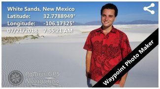
📡 Waypoint photography.
📡Map Search and Coordinate Conversion capabilities with the free MapIt! plug-in
📡 Improved compatibility for maritime navigation with addition of nautical and NOAA marine charts.
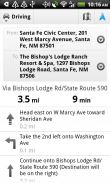
📡 Road navigation and street directions are provided through a digital pipeline connecting the power of Polaris to the Google Maps app on your device.
* The premium version of Polaris Navigation is called GPS Waypoints Navigator, available on Google Play. GPS Waypoints Navigator is ad-free and contains many other enhancements.
GPS berkinerja tinggi yang mudah digunakan untuk kemanapun perjalanan Anda membawa Anda. Tidak diperlukan pengaturan akun atau langganan.
Ubah ponsel Anda menjadi sistem navigasi GPS yang tangguh dengan GPS Navigasi Polaris, GPS serba guna # 1 di dunia, dan berani pergi ke tempat yang tidak ada jalan.
Bayangkan ... Seperti apa rasanya menavigasi jalan air atau menjelajahi hutan belantara atau kota hanya dengan menggunakan kemampuan lokasi GPS ponsel Anda dan pemandangan langit? Seperti apa rasanya membuat tujuan navigasi tanpa perlu koneksi internet dan menemukannya hanya menggunakan panah atau peta offline.
Itu hanya sekilas tentang kekuatan navigasi yang akan Anda pegang ketika Anda menginstal GPS Navigasi Polaris.
Digunakan sebagian besar sebagai aplikasi hiking, off road, laut, dan jejak GPS, Polaris adalah cadangan atau pengganti yang sangat baik untuk unit navigasi satelit GPS genggam khusus Anda dan akan membuat Anda tetap berorientasi ke mana pun petualangan luar ruangan membawa Anda!
Penggunaan umum:
● Hiking GPS dengan peta hiking terbaik!
● Kembali ke penjelajahan negara dan petualangan luar
● Perekam jejak
● Berlayar, Berperahu. Semua grafik navigasi laut di Polaris gratis.
● Memancing GPS. Temukan lubang memancing favorit Anda.
● Berburu dan berburu peta. Temukan Anda buta berburu favorit dan jalan kembali!
● Geocache
● Berkemah
● Peta Bersepeda Gunung dan sepeda
● Backpacking dan olahraga luar ruangan lainnya
● Orientasi kompas
Dikenal karena stabilitas, keandalan, dan fleksibilitasnya , Polaris digunakan oleh pencarian dan penyelamatan darat-laut, personel militer, dan jutaan lainnya di seluruh dunia.
Untuk mendukung petualangan offline Anda, kami menyediakan gratis:
📡 Akses ke pengunduh peta vektor & raster kami (topos, marinir, hiking, dan lainnya).
📡 Tidak ada batasan pada tipe peta atau jumlah unduhan peta.
📡 Semua peta ditampilkan dengan detail tinggi dan label besar, mudah dibaca.
Sistem navigasi yang kuat ini juga meliputi:
📡 Pemilih Tempat Polaris. Temukan jalur hiking, lokasi berkemah, dan banyak lagi lainnya!
📡 Kompas GPS dan kompas magnetik
📡 panel parameter GPS
📡 Odometer, altimeter, spedometer, kronometer
📡 Pisahkan jarak di trek
📡 Gambar jejak dan navigasikan
Maps Google Maps, OpenStreetMap-Mapnik, Peta Topografi, Rute Rute dan Hiking, Peta Vektor, Peta Topo USGS, Peta Laut NOAA, Peta Operasi Penerbangan Dunia, Peta Toporama Kanada.
📡 Perangkat GPS dan diagnostik yang lengkap
📡 Sistem navigasi waypoint termasuk kompas penemu waypoint dinamis yang selalu menunjuk ke tujuan Anda sambil melaporkan perkiraan waktu kedatangan, jarak ke target dan statistik lainnya. Ikuti saja panahnya!
📡 Sistem navigasi jejak
📡 Profil ketinggian
📡 Berbagi lokasi
📡 Mendukung OSGR Inggris dan OSGB-36 DATUM (Ordnance Survey Grid)
📡 Format koordinat: lintang / bujur sebagai derajat, deg: min, deg: min: dtk, dan UTM (Universal Transverse Mercator).
📡 Pencari Koordinat Militer - Sistem Referensi Koordinat Jejaring Militer (MGRS).
📡 Jalur Lintas Alam - Sebagian besar peta menunjukkan jalur hiking dengan izin dari proyek Openstreetmap. Kami selalu kagum menemukan bahwa bahkan beberapa rute hiking yang paling tidak jelas di negara bagian kami tersedia.
⚓ Navigasi laut - Diagram Bahari NOAA dan pelaporan unit laut.
⚓ Tanda drift / Seret jangkar alarm.
📡 Pilih sumber untuk pelaporan ketinggian: Satelit, Survei Geologi Amerika Serikat atau petakan lokasi Anda ke hasil Misi Topografi Radar Antar-Jemput Antariksa NASA
📡 Fotografi waypoint.
📡Peta Pencarian dan Koordinasikan kemampuan Konversi dengan MapIt gratis! plug-in
📡 Peningkatan kompatibilitas untuk navigasi maritim dengan penambahan grafik laut bahari dan NOAA.
📡 Navigasi jalan dan petunjuk jalan disediakan melalui pipa digital yang menghubungkan kekuatan Polaris ke aplikasi Google Maps di perangkat Anda.
* Versi premium Polaris Navigasi disebut GPS Waypoints Navigator, tersedia di Google Play. GPS Waypoints Navigator bebas iklan dan mengandung banyak perangkat tambahan lain .
Polaris GPS Navigation: Hiking, Marine, Offroad - Versi 9.25
(30-01-2024)
Polaris GPS Navigation: Hiking, Marine, Offroad - Informasi APK
Versi APK: 9.25Paket: com.discipleskies.android.polarisnavigationVersi Terakhir dari Polaris GPS Navigation: Hiking, Marine, Offroad
Aplikasi pada kategori yang sama
Anda juga mungkin suka...


